Gis
Component Source Code Links
Here are some useful add-in related
Gis
Component Source Code links
I've started collecting. This section is still very much under
construction, and more links will be appearing in the future. If any
Gis
Component
Source Code
link
dies, please contact
me.
"Diagramming
business logic when developing a custom application is a time-consuming,
tedious—and necessary—process. With E-XD++ Diagramming Source Code
Kit, you can spend more time focusing on the finer points of your
customer's business and less time worrying about making the business
process diagram look good. "
Add proto - logic diagram displays to your
Java, C++, and .NET applications, for the desktop and rich
internet applications.

First time here?
|
 Product
Tour Product
Tour
E-XD++ Gis Component product walkthrough
Screenshots
Applications built on E-XD++ Gis Component
Product
feature comparison
Powerful, flexible, and
easy to use Diagram Components.
Powerful and flexible enough to create diagrams exactly the way you want
them to appear. So easy to use that you will be able to prototype your
application in just a few minutes.
Feature rich.
With features such as automatic layout, multiple layers, collapsible
sub-graphs, snap-to connection points, XML, SVG, and more, E-XD++ Have the
power and flexibility you need to create sophisticated diagrams, quickly and
easily. Events such as click, double-click, hover, select, rubber-band
select, copy, delete, resize and move are supported. Operations such as
drag-and-drop, unlimited undo/redo, and clipboard operations are common and
complex, and are expected by today's sophisticated users. it full supports
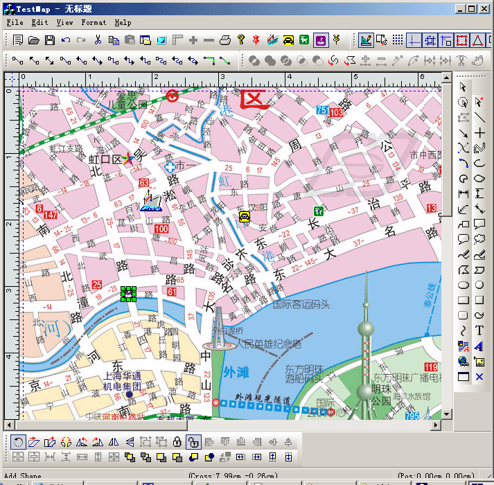
importing ArcGis, SVG and DXF File format.
Performance and
Scalability.
UCanCode E-XD++ Capable of handling many thousands of nodes and edges, up to
hundreds of thousands depending upon the complexity of the nodes you wish to
draw and the operations you wish to allow. Our graphical classes are
extremely lightweight objects enabling outstanding performance.
Save Time and Money and gain Reliability.
A diagram is worth 1,000 words, and E-XD++ is shipped with more than 500,000 lines of well designed and well tested code! It is used by hundreds of the world's most quality conscious companies. It will saves you thousands of hours of complex coding and years of maintenance. |
|
|
| We
Can Make Your Project Successful !
E-XD++
MFC/Gis Component Enterprise Edition is the the world’s
leading MFC/C++ visualization component (MFC/Gis Component
Source Code). Renowned for incredibly
rich graphics, E-XD++ MFC/Gis Component
Source Code helps developers build applications that offer
unparalleled functionality.
|
Outstanding productivity lowers project
risk and reduces maintenance headaches. With 8 years of dedicated
research and development, UCanCode leads the market for
visualization technologies, providing outstanding customer support.
with E-XD++ MFC/Gis Component
Source Code Enterprise you can easily build Visio
2003 like applications. |
| E-XD++
MFC/Gis Component
Library Professional Edition
is a MFC/Gis Component Source Code for developing Microsoft Visio like interactive 2D graphics and
diagramming applications. E-XD++ MFC/Gis Component
Source Code stores graphical objects in a node
(scene) graph and renders those objects onto the screen.
Visual
C++ MFC Library
|
E-XD++ MFC/Gis Component
product supports both vector and raster graphics on the drawing
surface. E-XD++ MFC/Gis Component
Source Code includes all the features of XD++
MFC/Gis Component Source Code
Professional Edition, it also includes many new important feature of
Visio 2003 or
Visio 2007. |
| UCCDraw
Gis ActiveX Control is an ActiveX control that allows creation
and editing of Visio-style
charts from within your application. Allows you to create Gis Components, vector drawings,
Gis
Component
Source Code,
raster images and more with the ability to
include hyperlinks and various shading and coloring effects. |
The base framework of
UCCDraw ActiveX Control is XD++ MFC/Gis Component
Source Code
You can
group objects together, include images and text, link them together
and apply custom drawing effects to create charts similar to
Microsoft Visio, Adobe Illustrator, and CorelDRAW |
|
XD++
MFC Library Standard Edition provides Microsoft
Foundation Class (MFC)/Gis Component
Source Code
developers
with a complete library of MFC extension classes which implement a
drag and drop (e.g. Visio) graphical interface. These classes fill
many of the holes existing in the Windows Graphics Device Interface
(GDI) and allow developers to incorporate custom graphical objects
and enhanced drawing capabilities into their applications.
|
All
of these classes fit seamlessly with MFC/C++, and inherit many of
MFC/C++'s
existing classes. Easily give your application a new look in
minutes!
The best component
for GIS development.
|
|
TFC
MFC/Gis Component
Gives you all the components your development
team needs to display or select date and/or time values in any
application. |
By including a Month calendar control, a Year calendar
control. TFC/C++ makes it easy to incorporate robust calendar features
in your program's interface today. |
A study on
the component classification in GIS
(Geographic Information System)
Yun-Won Jo, Myung-Hee Jo, Dong-Ho
Shin
Department of Urban Information Engineering, Kyungil University
33 Buho-ri, Hayang-up, Kyungsan-si, Kyungsan bukdo, 712-701, Korea
Tel : +82-53-850-7312,
Fax : +82-53-854-1272
1. Introduction
Recently many software engineers have focused on component research
to increase the reusability and interoperability. Especially, the
research of common repository system for architecture technology,
management, and development has been regarded as a big issue because
it can save time and manpower by accessing to exactly what system
developers are looking for.
System developers usually tend to spend much of their time and
effort to find out certain functionality for the implementation of
their preferred style. Also, they want to obtain guaranteed
component for improving their system productivity and quality at the
same time. However, as you know, it is very difficult to identify
certain components in a repository because of the lack of quality
software components and the inability of developers to efficiently
find them. Here, in order to solve this, establishing fully
repository architecture in the Web for component sharing and
circulation should be encouraged in a proper way.
In order to implement GIS
(Geographic Information System) more efficiently in the view of cost
and time, GIS developers started
to consider the concept of 揅omponent
GIS? It is mainly focused on reusability and interoperability
because most GIS projects have its certain application such as
MIS(Marketing Information System), ITS(Intelligent Information
System), LIS(Land Information System), DCS(Disaster Control System),
and FMS(Facility Management System) and each application needs its
common functionalities such as mapping and query or its certain
functionality such as 3D viewer and GPS data processing. Therefore,
if there exists a universal repository storing GIS components and
system designers or developers know where desired component blocks
are located in real time, GIS developers
can easily select their desired component then modify or composite
their system by using them.
In this paper, the metadata, which describe component, are the key
to the functionality of the repository. Therefore, metadata,
especially describe GIS components the most, should be first defined
then the architecture of a component repository should be
constructed.
2. Research Background in OGC (OpenGIS Consortium)
What is the first thing that GIS
application developers consider when they are developing
the application system? As you know, just like any other system
developers they must maintain its interoperability and reusability
by using previous component.
In this paper, the OGC (OpenGIS Consortium) is more focused as
related work because it has dedicated much time and effort towards
solving the interoperability issues outlined previously. The OGC is 搕he
full integration of geo-spatial data and geo-processing resources
into mainstream computing and the widespread use of interoperable
geo-processing software and geo-data products throughout the
information infrastructure? In order to facilitate this, its working
groups have developed abstract specifications and implementation
specifications for its two central technology themes of sharing
geo-spatial and providing geo-spatial services [1].
The Abstract Specifications [2]
The abstract specification documents provide the theoretical
background for the implementation specifications. The Open GIS
abstract specification documents are composed of two models: 1) the
essential model that describes a conceptual link between the
software system and the real world, and 2) the abstract Model that
describes how the eventual software system should work in an
implementation neutral manner.
Following lists briefly shows each category described in the Open
GIS abstract specifications; Overview, Feature Geometry, Spatial
Reference System, Location Geometry, Stored Functions and
Interpolation, The OpenGIS Feature, The Coverage Type, Earth
Imagery, Relationships between Features, Quality, Feature
Collection, Metadata, The OpenGIS Service Architecture, Catalog
Services, Semantics and Information, image Exploit Services, Image
Coordinate Transformation Service.
The Implementation Specifications
The Implementation Specifications documents are a set of
specifications that contain guidelines for implementing Open GIS
applications or components.
Following lists briefly shows each category described in the Open
GIS Implementation Specifications; Simple Features Specification,
Catalog Services Interface Implementation Specification, Grid
Coverage Implementation Specification, Coordinate Transformation
Services Implementation Specification, Web map Server Interface
Implementation Specification, Geography Makeup Language (GML)
Implementation Specification.
3. GIS Component Classification using Metadata
In order to classify GIS component, there are two views of
classification; 1) The functional component classification [3], 2)
The non-functional component classification.
The functional component classification in GIS considers following 4
layers. First of all, Infrastructure Component, which describes
general environment for developing component and executing such as
various platforms, operation systems, and networks environment.
Second, Data Provider Component, which has purpose to acquire
interoperability among them constructed under heterogeneous
environment, data provider component should be constructed. Third,
Core / Base Component, which can be used as the kernel of GIS by
developing certain GIS application software. There exist core
components to perform general GIS functions such as Data Provider,
Map Display, and Attribute Display also exists a base component to
perform certain GIS functions such Network Analysis, 3D Analysis,
and Authority. Forth, GIS Component, which shows several GIS domain
such as MIS (Marketing Information System), FMS (Facility Management
System), DCS(Disaster Control System), ITS(Intelligent
Transformation System), UIS (Urban Information System), and LIS(Land
Information System).
Even though there are certain components having reusability and good
quality, the rate of their reusability may be low because they have
difficulty to access in a repository. It is essential to express the
non-functional element to identify components. Here, two big
non-functional classification categories are discussed such as GIS
content-dependent metadata and GIS contents-independent metadata in
Fig. 1.
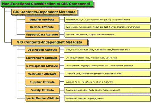
Figure 1 Non-Functional
Classification of GIS Component
GIS content-dependent metadata: As you see in the item name,
when metadata is associated with the original GIS domain
itself, we call it GIS Content-dependent metadata. Especially,
considering GIS component, there are three small categories related
to it; 1) Identifier Attribute, 2) Service Attribute, 3) Support
Data Attribute.
On the other hand, GIS content-independent metadata: it doesn抰
depend on the GIS domain. These
kinds of metadata can be derived independently from the content of
the GIS. There are seven small categories; 1) description Attribute,
2) Environment Attribute, 3) Development Attribute, 4) Restriction
Attribute, 5) Supplier Attribute, 6) Quality Attribute, 7) Special
Mention Attribute.
In Fig. 2, the needs of individual GIS system developers tend
to limit to what kinds of component they are accessing to on Web.
System developers can obtain certain functionality presented to them
in a way suiting their preferred style for its implementation. As
the result, they can save their time, effort, and cost through
on-line adaptation of GIS component in a repository. At this
time, Metadata query broker is working as a brokerage mechanism
supplied in the repository for the retrieval of various types
component. As stated before the original purpose of these metadata
query broker is to search the component that is usually associated
with implementation of GIS application. Especially, to avoid
storing multiple copies in a repository, each component should be
registered through CUID.
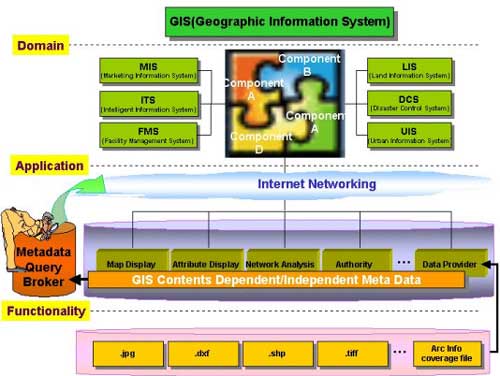
Figure 2 On-line Adaptation of GIS
Component
4. Prototype of GIS Component
Retrieval System on line
In this paper, the prototype of GIS component retrieval
system is presented to register new component and manage them and
retrieval related component effectively. Fig. 3 shows the prototype
of Web based GIS component retrieval system. To operate this
retrieval system, the non-functional GIS component
classification, metadata of each GIS,
is used.
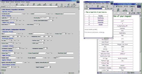
Figure 3 The Prototype of GIS
Component Retrieval System
5. Conclusion
In order to increase reusability higher, a large sized collection of
reusable software is a necessity. Recently, most research efforts
have been focused on not only the construction of repository that
contains a large number of components but also define metadata well
to retrieval.
In this paper, to operate GIS Component Retrieval System, two
types non-functional component classifications in GIS are
proposed; 1) GIS content-dependent metadata, 2) GIS
content-independent metadata. Also, the detail metadata item for
each are defined.
In the future, in order to increase component reusability in GIS
domain, these should be consideration for GIS component
repository management system using not only metadata described here
but also further extended metadata.
The
leader in visualization component -- FULL VC++ Source Code Shipped!
XD++ Diagrammer Suite is the the
world’s leading VC++ and .NET visualization component. Renowned for
incredibly rich graphics, XD++ helps thousands developers build
applications that offer unparalleled functionality. Outstanding
productivity lowers project risk and reduces maintenance headaches.
With 20 years of dedicated research and development, UCanCode leads
the market for visualization technologies, providing outstanding
customer support.
 GIS and SCADA,
SCADA Software With GIS, Real - Time Software with GIS, Source Code solution for C/C++, .NET GIS and SCADA,
SCADA Software With GIS, Real - Time Software with GIS, Source Code solution for C/C++, .NET
VC++ Example
Capture Print Screen to
Clipboard including
dropdown menu,
SetWindowsHookEx
and
UnhookWindowsHookEx,
with
RegisterWindowMessage
VC++ Example:
Draw or display Real-time data
plot Chart
Draw, Print and encode UPCA barcode
and UPCE barcode, and EAN13 barcode
with VC++ Codes
Open Source HMI / SCADA Software ToolKit, C# / C++ Codes
VC++
Article:
CTreeCtrl and GetRootItem, GetItemRect and
GetNextItem with Printing Tree View and CreateBitmap
Visual C++
Example:
Load DIB Bitmap File and Save Bitmap file and
Convert dib to bitmap and rotate bitmap file
Open Souce VC++ Code and MFC Code Site,
VC++ FAQ Site and Tutorial Site
MFC
Example:
CoInitializeEx and
SHBrowseForFolder
with file folder browser
CAD 2D Draw -
Geometry Library with VC++ Source Codes
OpenGL 3D Graph ActiveX Control
Screen Capture , to Clipboard, C++ Source Code,
Get bitmap of Window
WinCE MFC TCP
SOCKET AND UDP SOCKET Sample Codes
Visual C++ Article:
free image library
with
image viewer with
CxImage and CListCtrl
thumbnail images
.NET
Article:
Draw 2d and 3d text with GDI+, and Draw Shadow
text and Emboss text with Visual C++ Source Codes
MFC
GDI+ Sample:
gdiplus.lib with GdiplusStartupInput and GdiplusStartup with
GdiplusShutdown
VC++
Sample:
Multiple Views layout of
RepositionBars and DeferWindowPos with
RecalcLayout and UpdateAllViews
News:
1 UCanCode Advance E-XD++
CAD Drawing and Printing Solution
Source Code Solution for C/C++, .NET V2025 is released!
2
UCanCode Advance E-XD++
HMI & SCADA Source Code Solution for C/C++, .NET V2025 is released!
3
UCanCode
Advance E-XD++ GIS SVG Drawing and Printing Solution
Source Code Solution for C/C++, .NET V2025 is released!
Contact UCanCode Software
To buy the source code or learn more about with:
|
|
|